Geographic information
The Smolensk region is situated practically in the middle of the East-European Plain,
in the western part of the Russian Federation.
The total area of the Smolensk region is 49 786 km2, that equals the territory of
Danmark, Swissaland, Slovakia. The region has a favourable geographical position, as the
shortest ways, connected the centre of Russia with Western Europe, pass through its
territory.
The climate of the Smolensk region is temperate continental. The average temperature in
January is –8...10°C while in July is +17...18°C. The river Dnieper and its
tributaries the Desna and the Sozh rise in the Smolensk region. There also flow such big
rivers as the Ugra and the Vazuza – the tributaries of the Volga. There are several
hundreds of lakes in the region.
The regional centre – Smolensk with the population 325 500 people, is situated at a
distance of 400 km from Moscow.
The total population of the Smolensk region is 1 million 50 thousand people.
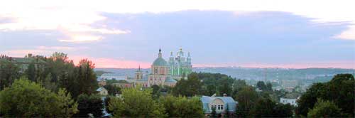
The view of the Cathedral of the Assumption and the Verhne-Georgievskaja Church, Smolensk